Time Domain Electromagnetic Geophysics
 Time domain electromagnetic sounding (TDEM) is a geophysical technique used by the Division of Water Resources to supplement data from our network of monitoring wells. TDEM surveys are most commonly used in eastern North Carolina to investigate the extent of saltwater intrusion within freshwater aquifers beneath the Coastal Plain.
Basic Principles:
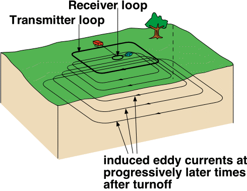
The time domain electromagnetic method employs a transmitter that drives an alternating current through a square loop of insulated electrical cable laid on the ground. The current consists of equal periods of time-on and time-off, with base frequencies that range from 3 to 75 Hz, producing an electromagnetic field. Termination of the current flow is not instantaneous, but occurs over a very brief period of time (a few microseconds) known as the ramp time, during which the magnetic field is time-varient. The time-varient nature of the primary electromagnetic field creates a secondary electromagnetic field in the ground beneath the loop, in accordance with Faraday's Law, that is a precise image of the transmitter loop itself (Halliday & Resnick, 1974). This secondary field immediately begins to decay, in the process generating additional eddy currents that propogate downward and outward into the subsurface like a series of smoke rings. Measurements of the secondary currents are made only during the time-off period by a receiver located in the center of the transmitter loop. Depth of investigation depends on the time interval after shutoff of the current, since at later times the receiver is sensing eddy currents at progressively greater depths. The intensity of the eddy currents at specific times and depths is determined by the bulk conductivity of subsurface rock units and their contained fluids (Stewart & Gay, 1986; Mills et al., 1988; Goldman et al., 1991; McNeill, 1994).
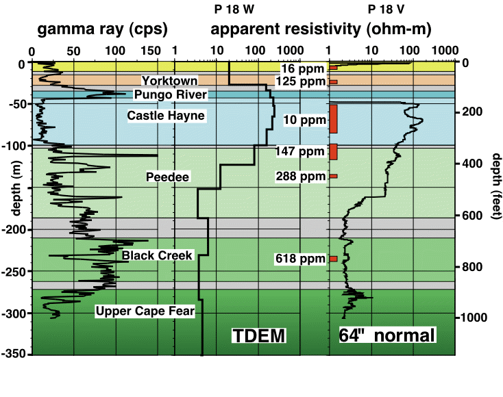
Because electrical conductivity is the inverse of resistivity, processing of the raw TDEM data yields a vertical profile of apparent formation resistivity vs. depth, similar to borehole resistivity profiles measured in monitoring wells with conventional logging tools. High resistivity values (greater than 10 ohm-m) usually result from the presence of fresh water in the subsurface. Resistivity values substantially less than 10 ohm-meters indicate that the groundwater at that depth is probably salty.
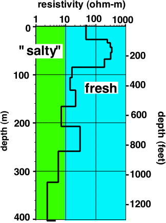
Compared to the cost of siting and drilling a new monitoring well, TDEM soundings can be made very quickly and cheaply. As the figure below indicates, resistivity data collected with TDEM compares favorably to borehole geophysical logs.
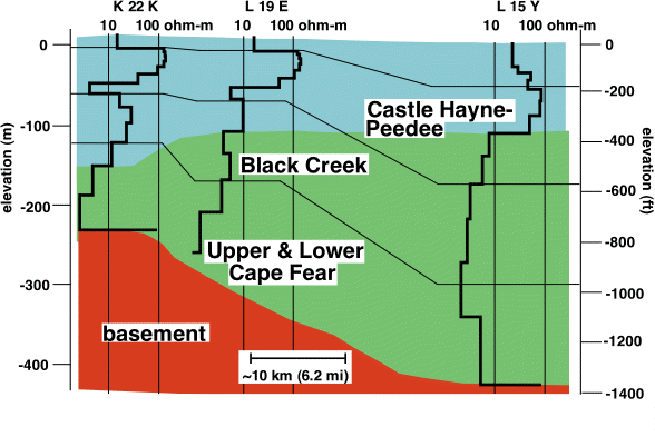
Saltwater encroachment into freshwater aquifers beneath the coastal plain is a serious problem in eastern North Carolina. When combined with information from boreholes, TDEM soundings can be used to help identify the interface between fresh and saltwater zones, and monitor the extent of saltwater intrusion.
References
Goldman, M., Gilad, D., Ronen, A., and Melloul, A., 1991, Mapping of seawater intrusion into the coastal aquifer of Israel by the time domain electromagnetic method: Geoexploration, v. 28, p. 153-174.
Halliday, D. and Resnick, R., 1974, Fundamentals of Physics: New York, John Wiley and Sons, 827 p.
McNeill, J. D., 1994, Principles and applications of time domain electromagnetic techniques for resistivity sounding: Geonics Ltd. Technical Note TN-27, 15 p.
Mills, T., Hoekstra, P., Blohm, M., and Evans, L., 1988, Time domain electromagnetic soundings for mapping sea-water intrusion in Monterey County, California: Ground Water, v. 26, p. 771-782.
Stewart, M. and Gay, M. C., 1986, Evaluation of transient electromagnetic soundings for deep detection of conductive fluids: Ground Water, v. 24, p. 351-356.