CCPCUA Strategy
North Carolina
Division of Water Resources
Central Coastal Plain Capacity Use Area Fact Sheet
Background
Groundwater pressure levels in the confined aquifers of the Central Coastal Plain have been declining for decades as groundwater withdrawals have increased. Up to a certain point, pressure level declines are a normal and acceptable part of groundwater use. However, if pressure level declines continue without stabilizing, it is an indication that groundwater is being withdrawn faster than it is being recharged, which can ultimately lead to reduced water yield and damage to the aquifers. The Division of Water Resources has been tracking coastal plain groundwater levels for a number of years. In early 1998, new monitoring data indicated that the declines had increased somewhat faster than predicted, and that in some areas dewatering of the top of the aquifers was occurring.
DWR held a workshop with groundwater users from the Central Coastal Plain in Greenville in March 1998 to review the monitoring data and discuss what responses should be made to assure a sustainable water supply for the coastal plain. Based on the available data and on this discussion with water users, the division has developed a three point program to assure good groundwater management in the coastal plain:
- Monitoring: An adequate groundwater level monitoring network must be operated, maintained, and improved as needed to provide accurate data on the amount and rate of groundwater level declines. This information is needed to guide management efforts to avoid damage to the aquifers and also to track progress in reversing water level declines through improved management.
- Planning: The solution to the water supply problems in the Central Coastal Plain will involve careful management of groundwater to use its sustainable yield while developing additional water sources to meet needs beyond those which can be met from groundwater. Communities in the Central Coastal Plain have a number of options for additional or augmented water supply sources, including surface water, use of aquifers which are less stressed, water conservation, water reuse, aquifer storage and recovery, and others. In 1998, local governments in North Carolina updated water supply plans for a twenty-year period into the future. The Division of Water Resources held a special workshop for Central Coastal Plain communities in Kinston on May 20, 1998 to give special emphasis to the need for planning supplementary sources to groundwater. These water supply plans were due by the end of 1998 and will provide an indication of the degree to which sustainable water supply plans are being developed.
- Regulation: The Water Use Act of 1967 provides a basis for regulating water withdrawals by permit in areas where water use is exceeding the capacity of a water supplies. The Water Use Act offers a method of preventing damage to the aquifers and of assuring that all water users have a predictable and fair access to water supplies. The Water Use Act alone cannot solve the water supply problem in the Central Coastal Plain, but must be used along with the monitoring and planning activities that complement it.
Reason for Proposed Capacity Use Area
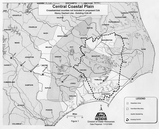
There is increasing evidence of present and future groundwater supply shortages within the area encompassed by the following 15 North Carolina counties: Beaufort, Carteret, Craven, Duplin, Edgecombe, Greene, Jones, Lenoir, Martin, Onslow, Pamlico, Pitt, Washington, Wayne and Wilson (see figure). Within these counties, groundwater from the Black Creek and Upper Cape Fear aquifers is being withdrawn at a rate that exceeds the available recharge. To address threatened groundwater supplies in the region, the North Carolina Division of Water Resources requested the Environmental Management Commission begin consideration of a capacity use area in December 1998. The Central Coastal Plain Capacity Use Area would regulate water use through permitting to avoid damage to the groundwater resources and to maintain the usefulness of those sources of water indefinitely.
Water levels in the Black Creek and Upper Cape Fear aquifers have been declining since the late 1960s, as documented by Division of Water Resources databases. The Division has anecdotal information from the 1920s that water flowed from artesian wells at the time they were constructed. This continued decline, from free-flowing wells to water levels as much as 200 feet below land surface, indicates that current withdrawals of water from these aquifers exceed the available supply that can be used on a sustainable basis. Regulating the use of water in this area fulfills the intent of the Water Use Act of 1967 to protect the resource from depletion and to allow water uses that can be sustained into the future.
Because demand for water exceeds the safe yields of the Black Creek and Upper Cape Fear aquifers, other sources of water must be brought on line by water supply systems. Surface water and other aquifers will be used to meet this deficit. The availability of surface water sources in these counties is affected by water quality issues. The high yielding Castle Hayne aquifer is available in the eastern portion of the affected area. This capacity use area is proposed to include those eastern counties to promote controlled development of sustainable alternative supplies. Because the proposed capacity use area encompasses all areas within the existing Capacity Use Area No. 1 that require continued regulation, the existing Capacity Use Area No. 1 declaration and rule (15A NCAC 2E .0201-0208) should be repealed when this proposed rule becomes effective.
The Water Use Act of 1967 allows for the Environmental Management Commission to
declare and delineate from time to time, and may modify, capacity use areas of the State where it finds that the use of ground water or surface water or both require coordination and limited regulation for protection of the interests and rights of residents or property owners of such areas or of the public interest.
The Act further states that a capacity use area
is one where the Commission finds that the aggregate uses of ground water or surface water, or both, in or affecting said area (i) have developed or threatened to develop to a degree which requires coordination and regulation, or (ii) exceed or threaten to exceed, or otherwise threaten or impair, the renewal or replenishment of such waters or any part of them.
The most threatened portions of the Black Creek and Upper Cape Fear aquifers lie beneath the following fifteen North Carolina counties: Beaufort, Carteret, Craven, Duplin, Edgecombe, Greene, Jones, Lenoir, Martin, Onslow, Pamlico, Pitt, Washington, Wayne and Wilson. The Division recommends that water use regulation take place in these counties (see attached figure).
The Division's recommendation is based on the following concerns:
- Water level drawdowns: Monitoring wells specifically designed to track water levels in the Black Creek and Upper Cape Fear aquifers show water level drawdown trends ranging from declines of one to eight feet per year. Those monitoring wells are distributed throughout an 8000 square mile portion of the central coastal plain.
- Dewatering: Water levels from water supply systems in several of these counties show drawdowns below the top of the aquifer by as much as 200 feet. Dewatering is known to cause irreparable harm to the aquifer's ability to yield water.
- Current and projected water use: Current and projected water use reported through the Local Water Supply Planning process {G.S. 143-355(l) & (m)} plus water use by other users have been compared to the estimated safe yield from the Black Creek and Upper Cape Fear aquifers. Projections through the year 2020 indicate a growing deficit in water supply. It is clear that other sources of water must be developed to make up this deficit.
Next Steps
Because of the urgency to avoid damage to aquifers and to begin the transition toward a sustainable water supply for the Central Coastal Plain, the Division of Water Resources recommended creating a new capacity use area at the meeting of the Groundwater Committee of the Environmental Management Commission on December 9, 1998. The Environmental Management Commission approved the draft rules at its meeting in March 1999.
Public comments received on those rules indicated that amendments were needed. The hearing officers requested that the Division develop a stakeholder group to revise the rules. That group completed its work in April 2000. In May 2000 the Environmental Management Commission approved the revised rules and the Division's request to proceed with permanent rule making. The Central Coastal Plain Capacity Use Area rules public comment period extended from July 17 through September 15, 2000 with afternoon and evening public hearings held on August 8, 2000. DWR and the hearing officers will bring the rules back before the EMC in October 2000.
The Division of Water Resources is searching for the most appropriate management measures to assure the permanent availability of groundwater to support the economy of eastern North Carolina. All interested parties are invited to share their ideas and information with the Division.